The massive deployment of wireless infrastructure especially in the trending 4th Industrial Revolution1 has opened the opportunity for wireless-based positioning and localization.
Wireless positioning system revolves on two techniques, the geometrical technique employing either triangulation or trilateration, and mapping technique employing signal fingerprint method.
This article will dive a little deep into both methods, with a general overview of Wi-Fi triangulation.
What is Wi-Fi Triangulation?
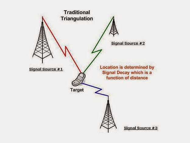
Wi-Fi triangulation (also known as trilateration) is a method used to find a device's location by analyzing the signal strength from nearby access points (APs). When devices search for Wi-Fi networks, they measure the signal strength (RSSI) of each detected AP, which is represented in decibels.

This technique relies on radio propagation models, such as Free Space Path Loss2 or Log-Distance Path Loss3, to estimate how signals weaken over distance.
Triangulation or Fingerprinting?
Fingerprinting positioning technologies use signal measurements across buildings to compute one’s position. It is based on the assumption that for every position there is an almost unique signal that can be recorded.
Fingerprinting is often used alongside Wi-Fi triangulation, where databases store signal strength patterns at known locations. These patterns are compared with observed data to estimate the device's location. Machine learning algorithms, (because why not also drag AI into this) have started to be used in order improve accuracy.
The use of more complex fingerprinting algorithm and state-of-the-art filtering techniques such as Kalman Filter4 has further increased the positioning accuracy.

Companies such as Google, Apple and Microsoft have been using Wi-Fi triangulation to identify your location, in order to track you and improve their services. The accuracy of Wi-Fi in the dense city can vary between 10 – 25m and in sub-urban areas with fewer access points 20 – 100m.
Within retail settings, Wi-Fi triangulation enables the tracking of customer movements, analysis of foot traffic patterns, and optimization of store layouts. By deploying multiple access points throughout a store, businesses can collect data on the location and movement of Wi-Fi-enabled devices, such as smartphones. This data enables retailers to identify popular areas of the store, measure dwell times at specific product displays, and assess the effectiveness of marketing campaigns or promotional events. Retailers leverage this information to make data-driven decisions about product placement, adverts, store layout, and marketing strategies, or/and sell that data for profit.
In emergency response systems, Wi-Fi triangulation enhances location-based services, situational awareness, and incident management. By leveraging Wi-Fi-enabled devices carried by individuals, such as smartphones or tablets, emergency responders can pinpoint their location in crisis situations, even in indoor environments where GPS signals may be unreliable. Access points deployed in public spaces, buildings, and transportation hubs capture signals from these devices, enabling emergency dispatchers to track the movements of individuals and coordinate response efforts more effectively.
Trilateration
Trilateration is the core principle of Wi-Fi triangulation, involving the calculation of where circles5 (in 2D) or spheres (in 3D) intersect around known APs. Multidimensional scaling algorithms refine these calculations by minimizing differences between measured and expected distances.
This means that your location can be accurately determined through having (at least) 3 APs in scanning range. This method can still be achieved using less than 3 APs but will become vastly less accurate if employed in such a scenario.

Real-time Wi-Fi positioning systems use sophisticated localization engines to process RSSI measurements, perform trilateration, and refine position estimates. These engines may also incorporate additional sensor data like accelerometers for improved accuracy.
Privacy Concerns
While Wi-Fi triangulation offers valuable location-tracking capabilities, it also raises privacy and security concerns.
One major concern is the potential for unauthorized tracking of individuals without their consent. Since Wi-Fi signals can penetrate walls and other physical barriers, it's possible for third parties to collect and analyze data on a person's movements without their knowledge, as was the case in the article above.
Additionally, the use of fingerprinting techniques, where databases store signal strength patterns at known locations, raises questions about the security and privacy6 of this data. If not properly secured, these databases could be vulnerable to hacking or misuse, leading to unauthorized access to sensitive location information.
Furthermore, as Wi-Fi triangulation becomes more widespread and accurate, it is increasingly being used for invasive or intrusive purposes, such as targeted advertising or behavioral profiling..
4IR: Industry 4.0, the Fourth Industrial Revolution, and 4IR all refer to the current era of connectivity, advanced analytics, automation, and advanced-manufacturing technology.
Free Space Path Loss: The Free Space Path Loss model focuses on how a signal weakens as it travels through open space without any obstacles or interference. Picture shouting across a wide, empty field – your voice weakens as it travels because it spreads out. Similarly, this model calculates how much a radio signal weakens based only on the distance it travels. It's a straightforward formula that considers factors like the frequency of the signal and the speed of light.
Log-Distance Path Loss: The Log-Distance Path Loss model is another way to predict how a radio signal weakens as it travels over distance. However instead of weakening evenly, it follows a logarithmic pattern. That means it starts to weaken slowly at first, then picks up speed as the distance increases.
Kalman Filter: The Kalman filter is a mathematical algorithm used for estimating the state of a dynamic system from a series of noisy measurements over time.
Where Circles: The term “Where circle” refers to a circular area on a map that represents the estimated location of a device based on signal strength measurements from nearby Wi-Fi access points.
PS: Note that under the GDPR, location data is considered personal data if it can directly or indirectly identify an individual. As such, organizations under GDPR collecting or processing location data must comply with GDPR requirements, including obtaining explicit consent from individuals, providing transparent information about data processing activities, and implementing appropriate security measures to protect the data.


